
RSP laser profiler: TMH 13 roughness survey
Ride quality and surface shape on paved roads: IRI, rut depth and macrotexture (MPD), with GNSS and DGPS positioning.
IRI.xyp · RD.xyp · GNSS.csv · DGPS.csv
Field data in. TMH 18 out.
Network-level road surveys: TMH 13 roughness (IRI), rutting and texture from the RSP laser profiler, FWD deflection surveys, and roughometer IRI on gravel roads. Every reading is fitted to your road register by road, lane and chainage, managed as one network survey and delivered as TMH 18 data for your RAMS.
TMH 13 covers our processing and reporting of roughness, rutting, texture, positioning and imaging. TMH 9 visual assessment is done in Visual Assessor.
60 s film, no narration (transcript in the page data). Footage: R33 Section 13, rear camera of the RSP survey vehicle. Music: RoadSense classical palette.
A network-level road survey uses different instruments for different questions. Each one is good at its job, and each one writes its own files.
Ride quality and surface shape on paved roads: IRI, rut depth and macrotexture (MPD), with GNSS and DGPS positioning.
IRI.xyp · RD.xyp · GNSS.csv · DGPS.csv

Structural strength: the deflection bowl under a dropped load, from the centre geophone outwards.
…_FWD.xyd · Dynatest .F25 / .FWD

Ride quality where a profiler doesn't go: IRI on gravel roads, measured in one wheel path.
ROUGH.csv · raw .rgd
The profiler counts its own station, the roughometer its own odometer, the FWD numbers its drops. None of them knows the client's chainage.
Road authorities budget by road, lane and kilometre of their own road register. A reading that isn't on the register can't be used.
A district survey is hundreds of runs over months. Someone has to know, every day, which roads are done, which are part-done and which are still to survey.
One platform, one project per survey, every reading row kept.
Road, lane and register km for every reading, in 10 m boxes.
Coverage per road and lane, QA checklist, what is left to do.
.cid and .fwd files, 10 m and 100 m, checked before delivery.
Crews upload every file from every instrument into a project on the RoadSense platform. The platform parses the readings and stores every row of IRI, MPD, rut, roughometer and FWD data, so nothing is thinned before it is used.
Your road register (the shapefile of roads, segments, surfaces and chainage) is the reference. Each reading is placed by its own GPS, not by a file name.
With every reading on the register, the survey becomes a map of the network. Coverage is recomputed by the platform on its own, the survey analysis and QA checklist follow, and each project shows its coverage per direction from GPS.
Every project is accounted for: of 529 projects, 484 are in the delivery, 33 have data off the register and 12 have no CID or FWD data. Each is listed with its reason.
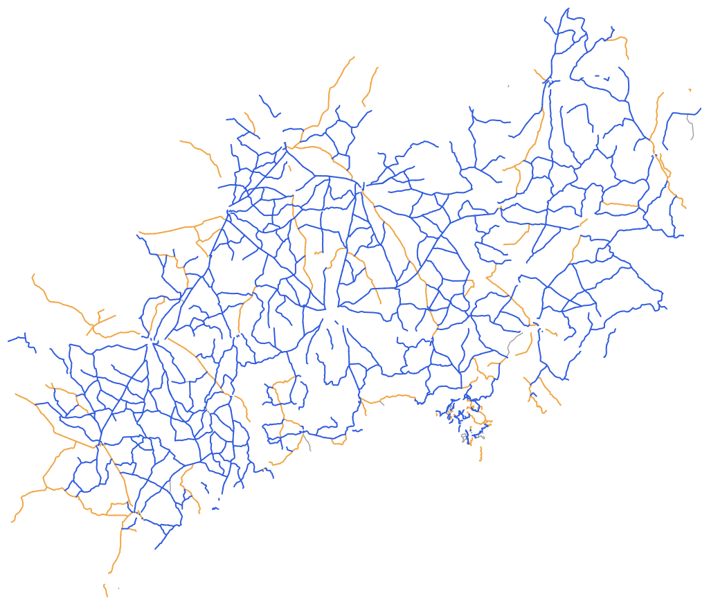
The delivery is written in the TMH 18 .cid (condition) and .fwd (deflection) file forms: no header row, as TMH 18 Table 1 sets out; ROAD_ID is the register segment; one file per surface at 10 m and 100 m. Readings that were not measured stay blank instead of being written as zero. These are the files a road authority loads into its road asset management system (RAMS), the process Draft TMH 22 describes.
Before delivery every file goes through the Meridian/V validation engine. The district delivery came back with 0 errors on every file.
| Delivery file (district client, 28 Oct 2026) | Rows |
|---|---|
| CLIENT_CID_Paved_10m.cid | 199,232 |
| CLIENT_CID_Gravel_10m.cid | 496,284 |
| CLIENT_CID_Block_10m.cid | 5,833 |
| CLIENT_CID_ALL_10m.cid | 701,354 |
| CLIENT_FWD.fwd | 38,225 |
Every claim names the edition and its scope, so a reviewer can check it.
| Standard | Edition | What RoadSense does to it |
|---|---|---|
| TMH 13 | Automated Road Condition Assessments (COTO), Committee Draft Final, May 2016Parts A General, B Positioning, C Roughness, D Rutting, E Skid resistance and texture, G Imaging | Processing and reporting: IRI, rut depth, texture (MPD), positioning, and survey imaging at 5 m stations, reported per 10 m and 100 m on register chainage.We don't yet claim TMH 13 Class 1 validation of the instrument itself. |
| TMH 9 | Visual assessment (COTO), Committee Draft Final, May 2016 | The visual assessment form and its outputs in Visual Assessor. See the visual assessment page. |
| TMH 18 | Road Asset Data Electronic Exchange Formats (COTO), Draft Version 4, October 2014 | Delivery in the .cid and .fwd file forms, checked with the Meridian/V engine before delivery. |
| TMH 22 | Road Asset Management Manual (COTO), Draft, March 2013 | Context: the TMH 18 files are the data a road authority's RAMS takes in. |
Reports are signed by a registered Professional Engineer (Pr Eng, ECSA).
Each figure below comes from a released platform change or a real delivery, and says how it was measured.
A profiler's own GPS receiver lost its fix and froze, so only 41 % of a 10 km survey could be placed. The platform now detects frozen fixes and re-places the rows along the RTK DGPS track by the profiler's own DMI distance.
Method: R33 Section 13, survey of 29 Oct 2026; IRI, MPD, rut and texture rows before and after the repair (GNSS rows 98.65 %). Released 31 Oct 2026.
Eleven delivery files, 701,354 condition rows and 38,225 FWD drops, checked with the Meridian/V validation engine before delivery.
Method: offline Meridian/V rule set of 21 July 2026 against the TMH 18 .cid and .fwd schemas. The FWD file carried 3 length warnings (negative bowl indices) and no errors.
Every road-lane is checked: a measured row more than 30 m from its own 10 m box fails the check. 14 road-lanes are flagged with the exact boxes; 181 have no condition data in that lane.
Method: each row's own GPS position against the register position of its box, per road and lane, on the district delivery of 28 Oct 2026.
Front-camera, back-camera and route coverage per direction, computed from each file's own GPS track for every project of a district client in one run.
Method: first live QA run after the release of 28 Oct 2026, 520 projects, 518 written.
A district road authority client (anonymised), delivery of 28 October 2026. Across all clients, 15,476.9 km of road registers are on the platform.
TMH 13, Automated Road Condition Assessments, is the COTO technical method for measuring road condition with automated equipment in South Africa. The current edition is the Committee Draft Final of May 2016, in parts covering general requirements, positioning, roughness, rutting, skid resistance and texture, and imaging. RoadSense processes and reports roughness (IRI), rutting, texture, positioning and imaging to TMH 13.
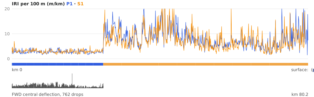
On paved roads the RSP laser profiler measures the longitudinal profile in each wheel path and IRI is computed from it with the quarter-car (Golden Car) model. On gravel roads a roughometer records the ride in the wheel path. RoadSense reports IRI per 10 m box and per 100 m on the client's register chainage; where a road is partly paved and partly gravel, the register surface decides which instrument is used first.
A falling-weight deflectometer drops a known load on the pavement and records the deflection bowl with geophones from the centre outwards. The bowl shows the structural strength of the pavement layers. RoadSense places every drop on the register by its own GPS and delivers the bowls, peak load, temperatures and bowl indices in the TMH 18 .fwd form.
The client's road register (a shapefile of roads, segments, surfaces and chainage) is the reference. Each reading is placed by its own GPS onto the nearest register road within 150 m, only when the run travels along that road, not across it. The lane comes from direction: with the register chainage is P1, against it is S1. Register kilometres are taken per segment and readings are binned into 10 m boxes. Data that cannot be placed is listed with its reason.
TMH 18, Road Asset Data Electronic Exchange Formats (Draft Version 4, October 2014), defines the file formats in which road condition data is exchanged, such as the .cid condition file and the .fwd deflection file. Road authorities load these files into their road asset management system (RAMS), whose process is described in Draft TMH 22, the Road Asset Management Manual (March 2013). RoadSense exports TMH 18 files at 10 m and 100 m, one per surface, and checks them before delivery.
TMH 9 is the COTO manual for visual assessment of road pavements (Committee Draft Final, May 2016). RoadSense covers TMH 9 visual assessment in the Visual Assessor desktop application: see visual assessment with Visual Assessor.
RoadSense survey reports are signed by a registered Professional Engineer (Pr Eng, ECSA).